|
| For Windows 11, 10, 8.x, 7, Vista and XP SP2/SP3 | |
| Precise pointing | |
| Maps up to 10000 x 10000 pixels | |
| No installation required |
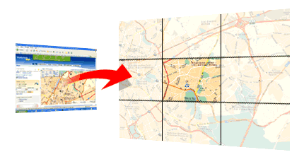
Prepare maps for your holidays, your walking, your bike trips, your geocaching... You can next print them or use them with your GPS!
If you think that maps found on the Internet are either not precise, or cover too small areas, MapCapt is for you!
This utility automatically scrolls, captures, assembles and saves maps (or other window content) from a Web page to a bitmap file, even if scrolling is controlled by custom controls. It can be used for example with maps.google.com (Globe mode disabled), www.viamichelin.com, www.randmcnally.com, www.geoportail.fr, maps.live.com, map.search.ch...
 How to use?
- Go to the desired Web site, maximize your browser window.
- Locate the desired area on the map and zoom to the desired scale.
- In order to MapCapt automatically realize the right scrolling, you have to parameter it according to the Web site.
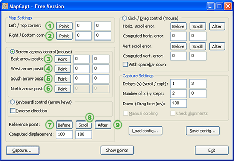
- Press the button 1 in MapCapt (see illustrations), next click on the left/top corner of the map. To avoid capturing the toolbar, you can define the corner just below it.
- Press the button 2 in MapCapt, next click on the right/bottom corner of the map.
MapCapt has three different capture methods.
- Click / Drag control (mouse).
The easiest method, to be used when the map moves when maintaining mouse button down on the map while moving the mouse.
- Most of the time, you can leave the four error parameters to 0.
- Check 'With spacebar down' when the map moves only when the spacebar of your keyboard is down.
- Screen arrows control (mouse).
 To be used with onscreen controller. Tip: a classic window scrollbar can be considered as an onscreen controller.
This method needs more parameterization.
- Press the button 3 and next, click on the control which scrolls the map towards east. Repeat this step for the west, south and north controls (buttons 4, 5 and 6).
- MapCapt also needs to know the amount of pixels for each scroll. Choose the button 7 and click next on a reference point in the map (in the bottom-right area of the map). This position must be precise, use the zoom window.
- By pressing the button 8, MapCapt will scroll the map once towards east and once towards south.
- Press the button 9 and click on the same reference point (which has scrolled); use once again the zoom window. The displacement is now computed.
- Keyboard control (arrow keys).
 To be used when map moves with the arrow keys of the keyboard.
This method needs more parameterization.
- MapCapt also needs to know the amount of pixels for each scroll. Choose the button 7 and click next on a reference point in the map (in the bottom-right area of the map). This position must be precise, use the zoom window.
- By pressing the button 8, MapCapt will scroll the map once towards east and once towards south.
- Press the button 9 and click on the same reference point (which has scrolled); use once again the zoom window. The displacement is now computed.
- You can now Save the settings for future use; each Web site will have its own settings.
 |
 |
 |
- Prior to start capturing, set the amount of horizontal and vertical steps you desire (free version is limited to 2 horizontal steps and no vertical scrolling).
- Press the button Capture.
- When MapCapt has finished, you'll see a dialog box to choose where to save the final image.
Download
This project is archived and is no more available.
Donationware
This project is archived and is no more available.
Links / Credits
OkMap
Xavier, Maciej, Jason, David, Mark, Gabor...
Disclaimer
This software is provided for demonstration purposes only. Personal use only. Use at your own risk. No technical support given. Don't copy or distribute copyrighted media.
Some Web sites can distort a little their maps so they don't align perfectly (for example www.mappy.com). Screen captures will never replace a bought genuine printed map.
![]() Last updated: 3/2022.
Last updated: 3/2022.